
Central Texas Grapples with Catastrophic Flooding as Guadalupe River Swells, Claiming One Life Amid Echoes of Last Summer’s Deadly Deluge
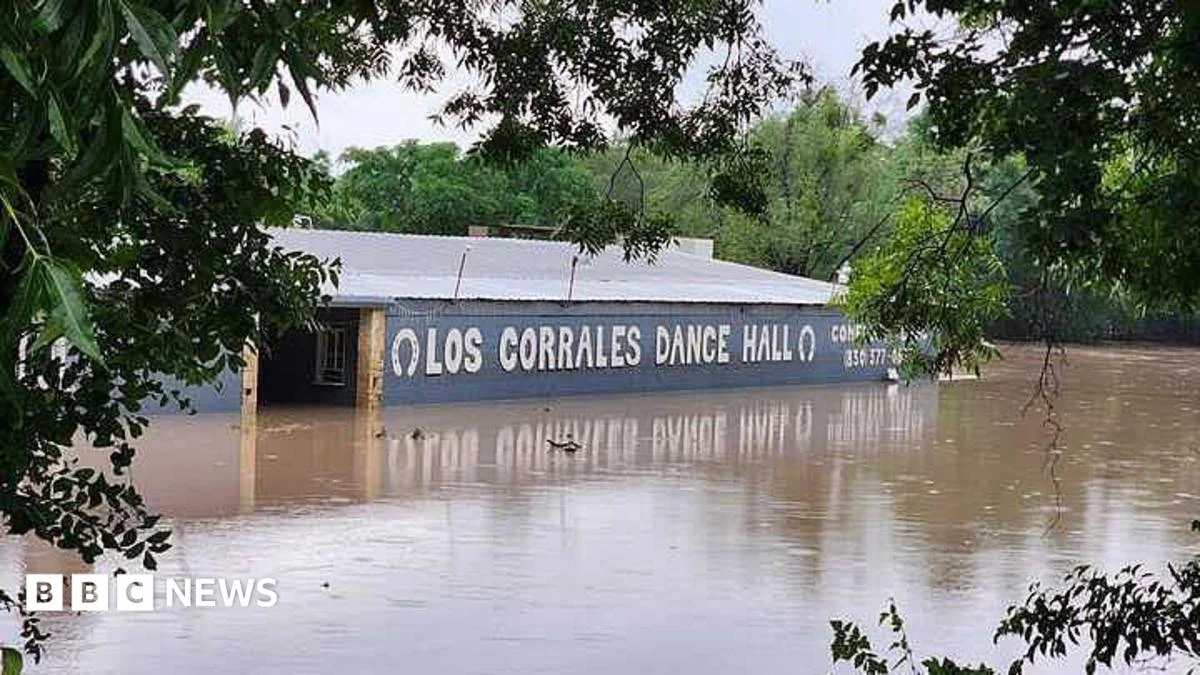
A state of emergency grips central Texas as torrential rains trigger widespread and "catastrophic" flooding along the Guadalupe River basin, resulting in at least one confirmed fatality and prompting urgent evacuation orders across multiple counties. The unfolding disaster revisits a harrowing chapter for the region, which less than a year ago endured devastating flash floods that claimed more than 130 lives, many of them along the very same river system. As emergency crews work tirelessly to conduct rescues and assess the rapidly evolving situation, the National Weather Service (NWS) has issued dire warnings, underscoring the extreme danger posed by rapidly rising waterways.
The Unfolding Crisis: A Chronology of Events
The genesis of the current flood event can be traced to several days of persistent, heavy rainfall that saturated the Texas Hill Country. By late Wednesday, localized flash flood watches had escalated to warnings as initial reports of rising creek levels began to emerge. However, the situation dramatically intensified in the early hours of Thursday morning.
At approximately 2:00 AM CST, emergency officials in affected counties, including Kerr, Kendall, and Uvalde, began issuing urgent advisories, encouraging residents in low-lying areas and along the Guadalupe River to seek higher ground. These initial warnings quickly transitioned into mandatory evacuation orders for specific communities as river gauges reported alarming rates of ascent.
By 7:00 AM CST, the National Weather Service in San Antonio amplified its alerts, utilizing social media platforms like X (formerly Twitter) to broadcast critical updates. One particularly stark warning read: "CATASTROPHIC flooding is occurring. Move to higher ground now! Guadalupe River is rapidly rising and will continue!" This message underscored the immediate and life-threatening nature of the floodwaters.
Mid-morning on Thursday, reports from local emergency services began to confirm the severity of the situation. Texas Governor Greg Abbott provided an update in the afternoon, announcing the tragic confirmation of at least one fatality associated with the flooding. While details surrounding the victim’s identity and circumstances were not immediately released, Governor Abbott did specify that the deceased individual was not a camper in the region, distinguishing the event from some of the tragic losses incurred during last year’s floods.
Concurrently with the fatality confirmation, the Governor reported that approximately 80 swift-water rescues had already been conducted by state and local emergency personnel, a testament to the rapid and dangerous inundation of homes and vehicles. These rescue operations, involving specialized teams and air assets, continued throughout the day as river levels continued to climb. The Texas Tribune reported an astonishing statistic: the Guadalupe River had risen an astounding 32 feet (approximately 975 centimeters) in just a four-hour span, illustrating the ferocity and speed with which the floodwaters advanced.
Throughout Thursday, the NWS continued to issue updates, adjusting flood crest predictions and expanding warnings to downstream areas, emphasizing that the "rapidly rising rivers" would continue to pose a significant threat for hours, if not days, to come. The cumulative effect of sustained rainfall, already saturated ground, and the unique geology of the Hill Country set the stage for this latest calamitous event.
A Region Under Siege: The Hydrology of the Guadalupe River
The Texas Hill Country, characterized by its distinctive limestone geology and often shallow, impervious soils, is inherently susceptible to flash flooding. When heavy rainfall occurs, the water has nowhere to soak in quickly, leading to rapid runoff that funnels into the region’s numerous creeks and rivers. The Guadalupe River, a major waterway stretching approximately 230 miles from its headwaters in Kerr County to San Antonio Bay on the Gulf of Mexico, is particularly notorious for its volatile nature.
The river’s upper reaches, where the current flooding is most severe, feature steep gradients and narrow canyons. This topography acts like a natural funnel, collecting vast volumes of rainwater from its tributaries and accelerating its flow. This phenomenon explains the extraordinary rise of 32 feet in just four hours reported by the Texas Tribune—a rate that can quickly overwhelm floodplains and low-lying communities.
The floodwaters have impacted a broad swath of South Central Texas, with initial reports focusing on Uvalde, Kerr, and Kendall counties. Kerrville, the county seat of Kerr County, sits directly on the Guadalupe River and has historically faced significant flood risks. Further downstream, communities in Kendall County, including Boerne and Comfort, are also highly vulnerable. Uvalde County, while not directly on the Guadalupe’s main stem in the same way, can experience severe flooding from its tributaries, which feed into the larger river system.
The sheer volume of rainfall preceding this event is a critical factor. While specific localized totals are still being compiled, meteorological data suggests that some areas received upwards of 10-15 inches of rain over a 48-72 hour period. This intense precipitation, falling on ground already saturated from previous rain events, significantly reduced the soil’s capacity to absorb any additional moisture, thus maximizing runoff into the river systems. The long-term average annual rainfall for this region is typically between 30-35 inches, meaning that some areas received nearly half their annual precipitation in a matter of days.
Historical records for the Guadalupe River reveal a consistent pattern of severe flood events, with notable deluges occurring in 1998, 2002, and most recently, in 2015. These events serve as stark reminders of the river’s potential for destruction, reinforcing the need for continuous vigilance and robust flood mitigation strategies.
Echoes of a Recent Tragedy: The 2015 Memorial Day Weekend Floods
The current flooding carries a heavy psychological weight for residents of central Texas, inevitably drawing parallels to the catastrophic Memorial Day Weekend floods of May 2015. That event, which saw record-breaking rainfall and unprecedented river levels, led to widespread destruction and an staggering loss of life. Over 130 people perished across Texas and Oklahoma, with a significant number of fatalities concentrated in the Blanco and Guadalupe river basins.
The 2015 floods were particularly devastating for communities like Wimberley, San Marcos, and numerous smaller towns along the Blanco and Guadalupe Rivers. Among the most heart-wrenching losses were 25 children and two counselors from Camp Mystic, an all-girls camp near Kerrville, Texas, situated directly along the Guadalupe River. While the current fatality has been reported as not a camper, the mere mention of Camp Mystic evokes a profound sense of sorrow and vulnerability for a region still grappling with the trauma of that previous disaster.
The 2015 event also highlighted the rapid onset nature of flash floods in the Hill Country. River levels rose by dozens of feet in mere hours, sweeping away homes, bridges, and vehicles with little warning for those caught in the direct path. Many residents recounted harrowing escapes, while others faced unimaginable loss. The recovery efforts from the 2015 floods were extensive, involving federal aid, volunteer organizations, and years of rebuilding infrastructure and homes. The psychological toll on survivors and affected communities has been profound, making the recurrence of severe flooding particularly distressing.
The shared geography and similar rapid escalation of river levels between the current event and the 2015 floods underscore the persistent challenge of living in a flood-prone region. Despite advancements in warning systems and public awareness campaigns, the sheer power of nature in this unique hydrological environment remains a formidable adversary.
Official Response and Emergency Operations
The response to the unfolding crisis has been multi-faceted, involving a coordinated effort between federal, state, and local agencies.
The National Weather Service (NWS) has been at the forefront of warning dissemination. Their meteorologists have been providing constant updates, leveraging Doppler radar, river gauges, and predictive models to forecast river crests and areas of greatest impact. Their explicit warnings, such as "CATASTROPHIC flooding is occurring. Move to higher ground now!", are designed to cut through ambient noise and convey the immediate threat, urging residents to take swift action. These warnings are crucial for triggering timely evacuations and allowing emergency services to pre-position resources.
Governor Greg Abbott has activated the state’s emergency response mechanisms. His statements emphasize the priority of saving human lives and underscore the commitment of state resources. The Texas Department of Public Safety (DPS) has deployed its specialized swift-water rescue teams, often utilizing helicopters and boats to reach stranded individuals. The Texas National Guard may also be activated to assist with high-water vehicle operations, security, and logistical support if the situation warrants broader deployment. Governor Abbott’s social media updates serve as a critical channel for real-time information and reassurance to the affected populace.
At the local level, County Emergency Management Offices in Uvalde, Kerr, and Kendall counties are coordinating on-the-ground efforts. This includes managing evacuation routes, establishing temporary shelters, and directing local fire departments, sheriff’s deputies, and volunteer rescue squads. The 80 rescues reported by Governor Abbott are a direct result of these brave local and state responders who put themselves at risk to save others. These operations often involve complex maneuvers in dangerous currents, highlighting the specialized training and equipment required for such emergencies.
Communication remains a key challenge during such events. Emergency alerts are broadcast through various channels, including local media, reverse 911 calls, social media, and the national Emergency Alert System (EAS). Public safety advisories consistently reiterate the life-saving message: "Turn Around, Don’t Drown," urging drivers never to attempt to cross flooded roads, as even a few inches of fast-moving water can sweep a vehicle away.
The Broader Implications: Economic, Environmental, and Social Impact
The economic fallout from severe flooding in central Texas can be substantial and far-reaching. Property damage is a primary concern, with homes, businesses, and agricultural infrastructure vulnerable to the destructive power of floodwaters. Even properties not directly inundated can suffer from compromised foundations, mold growth, and decreased property values.
Agriculture, a vital component of the central Texas economy, faces significant losses. Livestock can be swept away, crops submerged and destroyed, and topsoil eroded, impacting farmers and ranchers for months or even years. The tourism industry, particularly vibrant along the Guadalupe River with its numerous camps, resorts, and recreational activities, will also suffer immediate and potentially long-term setbacks as facilities are damaged and visitors defer plans.
Infrastructure damage is another major implication. Roads and bridges can be washed out, disrupting transportation networks, impeding emergency access, and requiring costly repairs. Utility services—power, water, and communication—are frequently interrupted, adding to the hardship faced by residents.
Environmentally, severe flooding can lead to significant erosion, altering riverbanks and habitats. The deluge also carries pollutants, debris, and sediment downstream, impacting water quality in the Guadalupe River and potentially affecting downstream ecosystems, including the delicate estuary system where the river meets the Gulf.
Socially, the psychological impact on communities is profound, especially given the recent memory of the 2015 floods. The anxiety, stress, and trauma associated with losing homes, possessions, and potentially loved ones can linger for years. Community resilience is tested, but often, these events also bring out the best in people, fostering neighborly support and collective rebuilding efforts.
Long-term, this recurring pattern of severe flooding necessitates a critical re-evaluation of flood mitigation strategies, land-use planning, and early warning systems. This includes investments in flood control infrastructure, stricter floodplain zoning regulations, and continuous public education on flood preparedness. The current event will likely trigger calls for increased federal assistance for both immediate relief and long-term recovery and resilience projects, similar to the aftermath of the 2015 floods.
Looking Ahead: Forecasts and Continued Vigilance
As of Thursday evening, the immediate threat posed by the rapidly rising Guadalupe River remained severe. While the heaviest rainfall may have passed for some areas, the sheer volume of water making its way through the river system means that crests in downstream communities will continue to occur over the next 24-48 hours. The NWS is maintaining flood warnings and watches, advising residents to stay informed through official channels.
Emergency operations will continue around the clock, with rescue teams remaining on high alert. Damage assessments will begin in earnest once floodwaters recede, a process that could take several days. The focus will then shift to providing aid to displaced residents, restoring utilities, and clearing debris.
The central Texas region is once again demonstrating its resilience in the face of nature’s power. However, the recurring nature of these catastrophic flood events underscores the urgent and ongoing need for comprehensive strategies to protect lives and property in a landscape inherently prone to flash floods. Continued vigilance, robust emergency planning, and sustained community preparedness will be paramount as central Texas navigates the immediate aftermath and prepares for the future.

Related Posts

Zambia on Edge: Opposition Leader Arrested Amid Allegations of Insurrection Plot and Election Tensions
Rescuers search for survivors of powerful Indonesia earthquake

