

Major Earthquakes Rock Eastern Indonesia, Triggering Tsunami Fears and Extensive Damage Across Multiple Provinces
Indonesia, a nation perpetually positioned along the volatile Pacific Ring of Fire, was once again thrust into a state of heightened alert and devastation following a series of powerful earthquakes that struck its eastern regions. The initial and most impactful event, a significant tremor, unleashed chaos and destruction, particularly in East Nusa Tenggara province, a testament to the devastating potential of shallow seismic activity. This major seismic event was quickly followed by a cascade of strong aftershocks, keeping residents in a state of terror and prompting widespread evacuations, while a separate, deep-seated earthquake later registered off the coast of North Sumatra, highlighting the archipelago’s pervasive seismic vulnerability.
The Initial Tremor and Immediate Aftermath
The primary earthquake, which sent tremors across a wide area, was notable for its relatively shallow depth, a factor universally recognized by seismologists as amplifying its destructive potential at the surface. The shallower an earthquake’s hypocenter, the less distance seismic waves have to travel through the Earth’s crust, meaning less energy is attenuated, resulting in more intense shaking and greater surface damage. This fundamental principle was tragically demonstrated in the port city of Maumere, located in Sikka, East Nusa Tenggara.
Eyewitness video footage captured the harrowing moments of impact at the port. Large chunks of concrete, dislodged by the violent shaking, were seen breaking off the terminal building, crashing down onto passengers who were waiting to board an inter-island ferry. The scene quickly devolved into panic and a desperate struggle for survival as the structural integrity of the port facilities crumbled. The gangway leading to a ship, a critical connection point for passengers, catastrophically collapsed, plunging some individuals into the sea amidst the debris and swirling waters. The immediate aftermath was one of confusion and rescue efforts as those nearby scrambled to assist the injured and stranded.
Tragically, the earthquake claimed lives, primarily due to the sudden and overwhelming force of collapsing structures. Emanuel Melkiades Laka Lena, the governor of East Nusa Tenggara province, conveyed the grim details at a news conference, stating that victims were killed in their sleep, caught unaware by the seismic event as their homes disintegrated around them. The vulnerability of residential structures, particularly in remote areas, to such intense shaking became painfully apparent.
A Nation on Edge: Aftershocks and Tsunami Alert
The initial jolt was not an isolated event. The affected region continued to experience a relentless succession of aftershocks, some of considerable magnitude, prolonging the fear and preventing any immediate sense of security. One of these aftershocks registered a magnitude of 6.1, a powerful earthquake in its own right, capable of causing further damage to already compromised structures and terrifying a populace already traumatized. These continuous tremors underscored the instability of the Earth’s crust in the wake of a major seismic rupture, as the fault lines continued to adjust and release accumulated stress.
Compounding the immediate danger and fear was the issuance of a tsunami warning by the Meteorology, Climatology, and Geophysical Agency (BMKG), Indonesia’s authoritative body for natural hazard monitoring. Given Indonesia’s tragic history with tsunamis, most notably the devastating 2004 Indian Ocean Tsunami and the 2018 Palu earthquake and tsunami, such warnings are taken with utmost seriousness. The sight of the sea receding, a classic precursor to a tsunami, was reported by residents in coastal areas, triggering widespread panic. Arnold Welianto, a resident of Talibura, a coastal village in Sikka, recounted his experience to the BBC, describing how he was abruptly awoken by "very strong shaking." He immediately rushed to his child’s room, a primal instinct of parental protection. Welianto further explained that many people had already fled into the hills, seeking higher ground in response to the tsunami threat. "Some other residents were standing along the roadside because the sea had also receded," he explained. "The water remained low for quite some time, so everyone panicked and ran – I went around to the community health centre, and the people there had already been evacuated."
The warning prompted a rapid, spontaneous evacuation effort. Streams of people could be seen moving inland on motorbikes, cars, and on foot, prioritizing safety over property. The National Disaster Management Agency (BNPB) later confirmed that approximately 2,000 people had evacuated or relocated on their own initiative, demonstrating the community’s ingrained awareness of tsunami risks and their proactive response. Fortunately, approximately three hours after the initial jolt, the tsunami warning was officially lifted when no significant sea level rise was detected. This reprieve, however, did little to quell the underlying anxiety caused by the persistent aftershocks.
Eyewitness Accounts: Stories from the Ground
The personal narratives emerging from the affected areas painted a vivid picture of the sheer terror and disruption caused by the seismic activity. Arnold Welianto’s account from Talibura highlighted not only the immediate fear but also the lingering apprehension. He noted that many residents of his village were choosing to remain outdoors, erecting makeshift shelters or simply staying in open spaces, as the incessant aftershocks made them afraid to return to the perceived instability of their homes. This psychological impact, the profound loss of safety within one’s own dwelling, is a common and enduring consequence of major earthquakes.
Further west of the epicentre, in the city of Ruteng, Yulian Juita Ekalia, a university lecturer, shared her equally unsettling experience. Her fear of further tremors was so acute that she had dragged her stove outside and was cooking in the open air. "I have never felt an earthquake this big," she told news agency AFP, her voice likely still laced with the shock of the event. Her description, "It felt like we were on a trampoline – it was really scary," vividly conveys the disorienting and violent motion experienced during the main tremor. These personal stories underscore the deep psychological toll earthquakes inflict, forcing communities to adapt to a new, unsettling reality where the ground beneath their feet can no longer be trusted.
Geological Context: Indonesia’s Tectonic Volatility
Indonesia’s unenviable position as one of the world’s most seismically active regions is a direct consequence of its location along the "Pacific Ring of Fire," a horseshoe-shaped belt around the Pacific Ocean characterized by frequent earthquakes and volcanic eruptions. This region is a hotbed of tectonic activity, where several major and minor tectonic plates converge, diverge, and slide past each other. Specifically, Indonesia lies at the meeting point of three major tectonic plates: the Eurasian Plate, the Indo-Australian Plate, and the Pacific Plate, with several smaller microplates adding to the complex geological dynamics.
The Indo-Australian Plate is subducting (diving) beneath the Eurasian Plate along the Sunda Arc, a curved chain of islands that forms the backbone of Indonesia. This subduction zone is responsible for the vast majority of Indonesia’s large and destructive earthquakes and its numerous active volcanoes. The continuous grinding and locking of these massive geological blocks build up immense stress over time. When this stress exceeds the strength of the rocks, it is suddenly released, causing an earthquake. The depth of these ruptures significantly impacts the felt intensity and potential for damage. As noted, shallower earthquakes, typically occurring within 70 km of the surface, transmit more seismic energy directly to the ground above, leading to more violent shaking and amplified surface effects compared to deeper earthquakes, where much of the energy dissipates before reaching the surface. The initial earthquake that struck East Nusa Tenggara was precisely this type of shallow event, maximizing its destructive power.
Indonesia’s history is punctuated by catastrophic seismic events. The 2004 Indian Ocean Tsunami, triggered by a magnitude 9.1 earthquake off Sumatra, claimed over 230,000 lives across fourteen countries, with Indonesia bearing the brunt of the devastation. More recently, the 2018 Palu earthquake and tsunami, a magnitude 7.5 event, caused significant liquefaction and landslides, leading to thousands of fatalities. These historical precedents inform Indonesia’s robust, though continuously challenging, disaster preparedness strategies and the immediate seriousness with which tsunami warnings are received.
Casualties and Widespread Destruction
The preliminary assessment of the earthquake’s impact revealed a grim tally of casualties and extensive structural damage across several provinces in East Nusa Tenggara. BNPB reported a total of three fatalities in Sikka province, six in Manggarai province, and five in East Manggarai province, bringing the initial death toll to fourteen. Beyond the fatalities, at least two individuals were reported to have sustained serious injuries, requiring intensive medical care, while eleven others suffered minor injuries. These figures are often dynamic in the immediate aftermath of such events and can unfortunately rise as more remote areas are accessed and comprehensive assessments are completed.
The physical destruction was widespread, affecting critical infrastructure and residential areas. Preliminary reports indicated that 54 houses had been severely damaged, rendering them uninhabitable and displacing numerous families. The impact extended to essential public services: five healthcare facilities sustained damage, disrupting medical provision at a crucial time. Three places of worship, six government buildings, an educational institution, and a warehouse were also among the structures reported to have been significantly affected. Manggarai province, in particular, was identified by BNPB as among the most affected areas, facing significant challenges in recovery and reconstruction. The remote and mountainous terrain of the region further complicates the assessment of the full extent of the destruction and the delivery of aid, making access challenging for relief teams and vital supplies.
The Broader Seismic Picture: A Separate Jolt in Sumatra
Adding to the regional seismic unease, a separate, powerful earthquake with a magnitude of 6.9 was felt later on Saturday off the coast of North Sumatra. Crucially, this event was recorded at a much greater depth of 183 km. While significant in magnitude, its deep hypocenter meant that its effects on the surface were considerably less destructive than the shallower East Nusa Tenggara quake. Although felt across a wide area, the energy from such a deep earthquake dissipates more effectively before reaching the surface, reducing the intensity of shaking and the likelihood of severe damage. This distinct event, while not directly related to the East Nusa Tenggara tremors in terms of immediate fault rupture, serves as a stark reminder of Indonesia’s pervasive seismic activity across its vast archipelago and the continuous underlying geological forces at play.
Official Response and Relief Efforts
In the face of the disaster, Indonesian authorities mobilized to manage the crisis and provide assistance. The National Disaster Management Agency (BNPB) took the lead in coordinating relief efforts, assessing damage, and disseminating information to the public. Their immediate advice was crucial: people were urged to remain calm, to stay away from coastal areas due to potential tsunami risks, and to avoid structures showing any signs of damage, as aftershocks could cause further collapses.
BMKG played a critical role in monitoring seismic activity and issuing the tsunami warning. Their ability to quickly analyze seismic data and communicate potential threats is vital in a country so prone to tsunamis. The swift lifting of the warning, based on scientific observation of no significant sea-level rise, helped to prevent prolonged panic while still ensuring initial caution.
Local government officials, such as Governor Emanuel Melkiades Laka Lena, were instrumental in communicating the situation to the public and coordinating local responses. Their presence on the ground, delivering news and directives, provided a sense of leadership and guidance during a chaotic time. The challenges for these officials are immense, encompassing rapid damage assessment, provision of emergency shelter and medical aid, and the long-term planning for reconstruction and rehabilitation in often geographically isolated communities. The initial self-evacuation of 2,000 people highlighted the community’s own agency and preparedness, a crucial element in disaster response in a country as vast and vulnerable as Indonesia.
The Road Ahead: Recovery and Resilience
The road to recovery for the affected communities in East Nusa Tenggara will be long and arduous. The destruction of homes, healthcare facilities, and other critical infrastructure necessitates significant reconstruction efforts. This will be particularly challenging in remote, mountainous areas, where logistical hurdles for transporting materials and aid are substantial. The economic impact on local communities, often reliant on agriculture, fishing, or small-scale trade, will also be considerable, requiring sustained support to rebuild livelihoods.
Beyond the physical reconstruction, there is a profound psychological toll that will need to be addressed. The fear of returning home, the trauma of experiencing such violent shaking, and the anxiety of ongoing aftershocks can lead to long-term mental health challenges for survivors. Community support, psychological first aid, and long-term counseling services will be vital in helping residents cope with their experiences and regain a sense of normalcy.
Indonesia’s continuous experience with seismic hazards has led to significant advancements in its disaster preparedness strategies. This includes the development of sophisticated early warning systems for earthquakes and tsunamis, public education campaigns, and regular disaster drills. However, each new event presents unique challenges and opportunities for learning and improvement. The resilience of the Indonesian people, often demonstrated in their ability to quickly organize and support each other in times of crisis, remains a crucial asset in their ongoing battle against the forces of nature. The need for resilient infrastructure, robust early warning systems, and continuous community education will remain paramount as Indonesia continues to navigate its dynamic geological landscape.

Related Posts

Zambia on Edge: Opposition Leader Arrested Amid Allegations of Insurrection Plot and Election Tensions
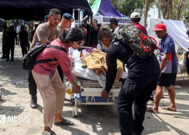
Rescuers search for survivors of powerful Indonesia earthquake

