Piton de la Fournaise Eruption Delivers Rare Ocean Encounter, Reshaping Reunion Island’s Landscape and Economy
Reunion Island, a French overseas department nestled in the Indian Ocean, has become the focal point of a mesmerizing natural spectacle as the Piton de la Fournaise volcano, one of the world’s most active, continues an eruption that commenced over a month ago. On Sunday, March 17, 2024, a significant milestone was reached when a river of molten rock, incandescent and inexorable, flowed into the Indian Ocean for the first time in 19 years, creating a dramatic interface between fire and water. This rare event has drawn an unprecedented number of both local residents and international tourists, all eager to witness the raw power of the Earth’s geological forces. The ongoing eruption, the second this year for the formidable shield volcano, has not only captivated observers but also posed significant logistical challenges, with lava flows intermittently cutting the national highway that serves as a vital artery linking the southern and eastern regions of the island.
A Volcanic Spectacle Unfolds: The Ocean Entry
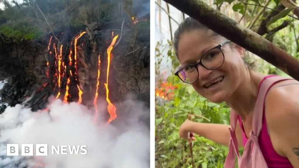
The moment lava met the sea on Sunday morning was a profoundly impactful event, both visually and scientifically. As the superheated basaltic lava, estimated to be around 1,000 to 1,200 degrees Celsius, cascaded over the coastal cliffs and plunged into the relatively cool ocean waters, it triggered a series of dramatic reactions. Towering plumes of white steam, laden with hydrochloric acid and microscopic glass particles (known as "laze" – lava haze), billowed skyward, creating a striking contrast against the azure sky. Explosions, known as littoral explosions, occurred as trapped seawater rapidly vaporized, shattering chunks of the cooling lava and ejecting incandescent fragments. This process rapidly began to build new land, forming a nascent lava delta that slowly expanded into the ocean.
For onlookers, positioned safely at designated viewing points established by local authorities, the scene was one of primal awe. The vivid orange and red glow of the lava against the dark rock and the shimmering sea, particularly pronounced during twilight hours, created an unforgettable panorama. Scientists from the Observatoire Volcanologique du Piton de la Fournaise (OVPF) were quick to seize this invaluable opportunity, deploying specialized equipment to study the lava-ocean interaction, collect gas samples, and monitor the chemical composition of the plumes. The last time such an event occurred was in 2004, making this a generational observation for many islanders and a critical data point for volcanologists studying effusive eruptions and their environmental consequences.
Piton de la Fournaise: A Geological Powerhouse
Piton de la Fournaise, meaning "Peak of the Furnace," is a basaltic shield volcano that constitutes the southeastern one-third of Reunion Island. Rising to an elevation of 2,632 meters (8,635 feet) above sea level, it is one of the most active volcanoes globally, characterized by frequent, typically effusive eruptions that produce fluid lava flows rather than explosive pyroclastic events. This characteristic makes it relatively safe for observation, provided proper safety protocols are followed. The volcano is largely contained within the Enclos Fouqué, a large caldera formed by the collapse of previous volcanic structures, with the central eruptive cone and its associated craters nestled within this vast amphitheater.
Reunion Island itself is a testament to volcanic activity, having been formed by a hotspot in the Earth’s mantle, similar to the Hawaiian Islands. It is the youngest of the Mascarene Islands, having emerged from the ocean floor approximately three million years ago. Piton de la Fournaise’s consistent activity is responsible for the continuous growth and reshaping of the island’s eastern flank, with past eruptions adding significant landmass to its coastline. Its geological significance is underscored by its inclusion within the Reunion National Park, a UNESCO World Heritage site recognized for its dramatic volcanic landscapes, deep canyons, and unique biodiversity. The volcano’s eruptions are often preceded by periods of increased seismic activity and ground deformation, meticulously monitored by the OVPF.
A Chronology of Activity: From Seismic Rumblings to Ocean Interface
The current eruptive phase of Piton de la Fournaise began on February 13, 2024, marking its second eruption within the calendar year, following a brief but intense period of activity earlier in January. Prior to the February 13 event, the OVPF had reported a noticeable increase in seismic tremors and deformation of the volcano’s summit area, indicating the ascent of magma towards the surface.
Key Chronology:
- Early February 2024: Heightened seismic activity and inflation of the summit caldera are detected by the OVPF monitoring network.
- February 13, 2024, 08:30 local time: The OVPF issues an alert confirming the onset of an eruption. Initial fissures open on the eastern flank within the Enclos Fouqué, leading to the rapid emission of lava flows. The prefecture immediately activates the "Vigilance Phase" of its ORSEC Volcan Plan, restricting access to the Enclos Fouqué.
- Mid-February: Lava flows progress steadily downslope, primarily towards the east. The high volume of lava and its sustained flow rate quickly begin to pose a threat to infrastructure.
- Late February: One significant lava flow crosses the Route Nationale 2 (RN2), the coastal highway, in the Sainte-Rose sector, effectively severing the critical link between the south and east of the island. This necessitates the implementation of lengthy detours and significant disruption to daily commutes and commercial transport. Efforts begin to clear and potentially rebuild sections of the road.
- Early March: While some initial flows cool and harden, new vents and lava tubes continue to feed the active flows. The OVPF maintains constant vigilance, noting variations in tremor intensity and lava effusion rates.
- March 10-15: Monitoring data indicates a sustained, high-volume lava output. Flows accelerate their descent towards the coast, raising anticipation among scientists and the public about a potential ocean entry.
- March 17, 2024, Morning: After weeks of relentless advance, one of the main lava flows reaches the shoreline and plunges into the Indian Ocean, marking the first such event since 2004. This dramatic interface draws large crowds, managed by gendarmerie and civil protection units.
- Post-March 17: The eruption continues, though the ocean entry point may shift or new flows emerge. The OVPF continues to monitor the activity, providing regular updates on the volcano’s behavior and potential hazards, including the "laze" plume.
The highway disruption, a recurring consequence of Piton de la Fournaise’s activity, highlights the delicate balance between living with an active volcano and maintaining modern infrastructure. While locals are accustomed to such events, the scale of the current disruption has led to calls for long-term solutions, including potential elevated road sections or alternative routes resilient to lava flows.
Monitoring the Beast: The Role of the OVPF
The meticulous tracking of Piton de la Fournaise’s activity is the responsibility of the Observatoire Volcanologique du Piton de la Fournaise (OVPF), a branch of the Institut de Physique du Globe de Paris (IPGP). Established in 1979, the OVPF operates a sophisticated network of sensors across the volcano, providing real-time data that is crucial for forecasting eruptions and mitigating risks.
The monitoring system comprises:
- Seismometers: Over 100 seismic stations detect ground vibrations, allowing scientists to pinpoint the movement of magma beneath the surface and identify precursors to eruptions.
- GPS Receivers and Inclinometers: These instruments measure ground deformation, revealing inflation (swelling) or deflation (subsidence) of the volcano as magma accumulates or drains.
- Gas Sensors: Stations continuously measure the emission of volcanic gases, such as sulfur dioxide (SO2) and carbon dioxide (CO2), which can indicate changes in magma depth and ascent rates.
- Thermal Cameras and Satellite Imagery: These technologies track the temperature of lava flows and provide broad overviews of their progression, particularly in remote or inaccessible areas.
- Webcams: Strategically placed webcams offer continuous visual surveillance of the eruptive sites, allowing for immediate observation of new fissures or changes in flow patterns.
The OVPF’s scientific team works around the clock, analyzing vast amounts of data to provide accurate and timely advisories to the Prefecture of Reunion. Their expertise is vital for informing public safety measures, determining access restrictions, and contributing to the global understanding of volcanic processes. The current ocean entry provides a unique opportunity for them to study the rarely observed phenomenon of lava-ocean interaction in detail, contributing valuable data to volcanology.
Impacts and Adaptations: Life on a Volcanic Island
Living on Reunion Island means coexisting with a dynamic geological landscape, and the ongoing eruption of Piton de la Fournaise exemplifies this unique relationship. The impacts are multifaceted, touching upon infrastructure, the environment, the economy, and the daily lives of its approximately 870,000 inhabitants.
Infrastructure Disruption: The cutting of the RN2 highway is perhaps the most tangible immediate impact on daily life. This vital coastal road, often referred to as the "Route des Laves" (Lava Road) due to its frequent encounters with molten rock, plays a critical role in connecting the densely populated west and north with the more rural east. Its closure forces commuters and goods traffic to undertake long, arduous detours across the island’s interior, significantly increasing travel times and transportation costs. Local authorities and engineers are constantly evaluating methods to protect or rapidly reconstruct sections of the highway, a testament to the island’s ongoing adaptation to its volcanic environment.
Environmental Concerns: While the creation of new land is a natural process, the lava-ocean interaction does present environmental concerns. The "laze" plume contains fine glass particles and corrosive hydrochloric acid, posing respiratory hazards to those nearby and potentially affecting local vegetation. The thermal shock and altered water chemistry in the immediate vicinity of the lava entry point can also temporarily impact marine ecosystems, though life typically re-establishes itself once the activity subsides. However, for a designated UNESCO biosphere reserve, continuous monitoring of long-term ecological changes is paramount.
Tourism Boost: Paradoxically, the eruption has also provided a significant boost to Reunion’s tourism sector. "Volcano tourism" is a well-established niche on the island, and the current spectacular ocean entry has drawn both local and international visitors. Tour operators report increased demand for helicopter tours, guided hikes to safe viewing points, and accommodations in the eastern regions. The island’s tourism board actively promotes the event, emphasizing safe viewing practices and highlighting the unique opportunity to witness one of nature’s grandest displays. This influx of visitors provides a welcome economic stimulus, offsetting some of the logistical challenges.
Local Resilience: Islanders demonstrate remarkable resilience and a pragmatic approach to living alongside an active volcano. Generations have learned to adapt to eruptions, understanding that Piton de la Fournaise, though powerful, is generally effusive and predictable. Safety protocols are well-understood, and the community largely trusts the advisories issued by the OVPF and the Prefecture. This familiarity fosters a sense of collective preparedness and a shared appreciation for the island’s unique geological heritage.
Official Responses and Public Safety
In response to the eruption, the Prefecture of Reunion immediately activated the ORSEC Volcan Plan, a comprehensive emergency response framework designed to manage volcanic hazards. This plan outlines specific phases of alert, corresponding to the volcano’s activity level, and dictates access restrictions, public information campaigns, and resource deployment.
- Restricted Access: The most immediate measure is the closure of access to the Enclos Fouqué, the caldera where the eruption is occurring. This is enforced by gendarmerie patrols to prevent individuals from venturing into hazardous areas where conditions can change rapidly. Designated safe viewing points, usually outside the Enclos, are often established and clearly marked.
- Public Information: The Prefecture, in close collaboration with the OVPF, issues regular press releases and public advisories, detailing the volcano’s status, the progression of lava flows, and any new safety recommendations. This ensures that residents and visitors are kept informed and can make informed decisions.
- Infrastructure Management: Engineering teams from the Departmental Directorate of Territories and the Sea (Direction Départementale des Territoires et de la Mer – DDTM) are on standby to assess damage to roads and other infrastructure, and to plan for emergency repairs or alternative routes.
- Environmental Monitoring: The regional health agency (Agence Régionale de Santé – ARS) monitors air quality, particularly for "laze" plumes, and issues health recommendations for vulnerable populations, such as those with respiratory conditions.
The coordinated efforts of these various agencies underscore the proactive approach taken by French authorities in managing natural hazards in their overseas territories. The priority remains the safety of the population while allowing for the scientific study and appreciation of this natural phenomenon.
Economic and Environmental Ramifications
The eruption of Piton de la Fournaise, while disruptive, also carries significant long-term economic and environmental implications for Reunion Island.
Economic:
- Tourism Boom: The immediate boost to tourism is undeniable. The unique spectacle attracts a niche market of adventure tourists and nature enthusiasts, generating revenue for local businesses, tour operators, and accommodation providers.
- Infrastructure Costs: The costs associated with road repair, maintenance of alternative routes, and potential long-term infrastructure adjustments (e.g., lava-resistant bridges or tunnels) represent a significant expenditure for the local government.
- Agricultural Impact: While the main agricultural zones are typically not directly threatened by Piton de la Fournaise’s effusive flows, indirect impacts such as ashfall (minimal in effusive eruptions but possible), air quality issues, or disruptions to transport chains can affect agricultural production and distribution.
- Scientific Investment: The island’s status as a living laboratory for volcanology attracts international scientific collaboration and funding, supporting local research institutions and fostering a highly skilled scientific workforce.
Environmental:
- Land Creation: The most striking environmental impact is the creation of new land. As lava cools and solidifies, it forms new coastal areas, gradually expanding the island’s footprint. These new lava deltas, while initially barren, eventually become sites for pioneering plant species, contributing to the island’s unique biodiversity over geological timescales.
- Marine Ecosystems: The immediate thermal and chemical shock from lava entering the ocean can cause localized mortality of marine life. However, these effects are generally localized and temporary. Scientists also study the potential for new microbial ecosystems to thrive in these extreme environments.
- Atmospheric Impact: The "laze" plume, while localized, contains pollutants. On a larger scale, volcanic eruptions contribute to atmospheric gas cycles, though Piton de la Fournaise’s effusive nature typically has a smaller global atmospheric impact compared to explosive eruptions.
Reunion Island: A Unique Ecosystem Under Volcanic Influence
Reunion Island’s identity is inextricably linked to its volcanic origins. Beyond Piton de la Fournaise, the island is dominated by the dormant Piton des Neiges, its highest peak, and characterized by dramatic cirques (natural amphitheatres) like Salazie, Cilaos, and Mafate. This rugged topography, coupled with a diverse climate ranging from tropical coastal zones to temperate highlands, has fostered an extraordinary level of biodiversity and endemism. The island’s rich ecosystems, including its unique forests, provide habitats for numerous species found nowhere else on Earth.
The volcanic activity, while occasionally disruptive, is also the very force that has sculpted this landscape, creating fertile soils and contributing to the island’s stunning natural beauty. This continuous geological renewal makes Reunion Island a prime location for studying not only volcanism but also ecological succession, adaptation, and the resilience of life in dynamic environments. It serves as a potent reminder of the Earth’s enduring power and the intricate web of life that adapts to its relentless forces.
Looking Ahead: The Enduring Rhythm of Eruption
As the current eruption of Piton de la Fournaise continues its rhythm, occasionally punctuated by new fissures, changes in flow direction, or spectacular ocean entries, the island of Reunion remains a vibrant testament to the power of nature. The current activity serves as a powerful reminder of the volcano’s constant presence and its role as a fundamental shaper of the island’s past, present, and future. While challenges like infrastructure disruption persist, the scientific insights gained, the economic boost from volcano tourism, and the ingrained resilience of the local population underscore a harmonious, albeit dynamic, coexistence. The world watches as Piton de la Fournaise continues to rewrite the landscape, one molten flow at a time, reinforcing its status as one of Earth’s most captivating natural wonders.
Related Posts
US Launches Eighth Consecutive Night of Strikes on Iran, Targeting Coastal Defenses Amid Escalating Regional Tensions
Russia’s Escalating Shadow Economy Undermines War Chest Amidst Worsening Fiscal Strain